“Learning and innovation go hand in hand. The arrogance of success is to think that what you did yesterday will be sufficient for tomorrow.” - William Pollard

Finding alternative ways to experience Sleeping Bear NATURALLY
As a group, we have advocated for experiencing Sleeping Bear Naturally; thus our name and vision. We believe that nature should be experienced naturally. It is important for people to experience nature without having to destroy the very thing we are trying to showcase. If you are impacting or altering something in order to create a more accessible experience, you have likely chosen the wrong path. It’s about letting people enjoy the peace and majesty of nature without paving a wide asphalt path right through it. We also believe low-impact trail construction and use of natural materials is desirable and more sustainable.
There are win-win alternatives that create recreational opportunities while still finding different non-vehicular ways for people to get out of their cars and enjoy nature. The recent engineering analysis by Mansfield Land Use Consultants identified alternative options for the proposed Segment 9 Sleeping Bear Heritage Trail. Those are summarized and described below. Open community dialogue around alternatives is always healthy and prudent. These alternatives meet all of the following objectives, consistent with those outlined in the 2009 NPS Trailway Plan, and provide a better alignment in meeting those objectives and guidelines than the proposed Segment 9. A PDF summary of alternative maps can be found here. Mansfield suggests that each of the alternatives are feasible and could result in savings of $10 million without removing thousands of trees. These alternatives create desirable recreational opportunities, have design flexibility, demonstrate environmental stewardship and are fiscally responsible.
It is important to look at a broader planning view of recreational opportunities within the Good Harbor area at this northeastern end of the Lakeshore. The ultimate destination goal is access to Good Harbor Bay and for visitors to enjoy Lake Michigan. There are alternatives in the Segment 9 region of the Lakeshore that accomplishes and meets all the proposed goals and purposes, including connecting to features in the Good Harbor area: Bohemian Beach, Good Harbor Bay Picnic Area, Shalda Creek Rest area, Shell Lake, and Lake Michigan beach - all designated recreational priorities within the NPS General Management Plan.
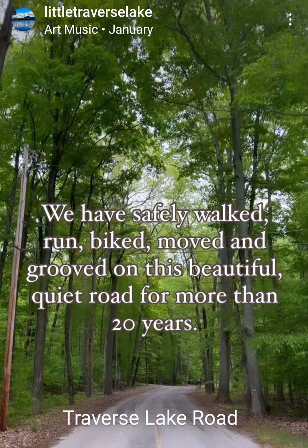
It is unfortunate that TART Trails and NPS seem to have a narrow view limiting the proposed Segment 9 trail to only a line along Traverse Lake Road and through the wilderness that ends at 651 in the middle of nowhere.
Goals of alternative options
Introduce visitors to the sights and sounds of Lake Michigan with access to Good Harbor Bay, showcasing the northeastern end of Sleeping Bear Dunes National Lakeshore
Provide a way for people to engage in healthy non-motorized activity
Strengthen connections to existing trailheads and points of interest
Enhance the recreational experience within the Lakeshore
Incorporate design standards and principles that meet accepted safety guidelines for trail alignment, cross-sectional design, and trailhead development
Avoid impacts to the environment and ecosystems
Avoid impacts to historic properties, archeological resources and private property


Create a Heritage Walking Trail loop
Recreational opportunities do not have to be limited to just a paved 10’ asphalt path. The Heritage Trail should not be limited to just having users walk, run, bike or ski on the same path. Sometimes the best way to experience nature is a low-impact walking path, especially through sensitive or vulnerable ecosystems. One of the goals of the Heritage Trail concept was to connect recreational paths and for people to engage in healthy non-motorized activity. A prime opportunity for a low-impact Heritage Walking Trail awaits in this Good Harbor region. There are 22 miles of paved trail options for visitors, mostly used by bicyclists. Let’s create an experiential trail for walkers to enjoy nature in its more natural environment as part of the Heritage Trail experience.
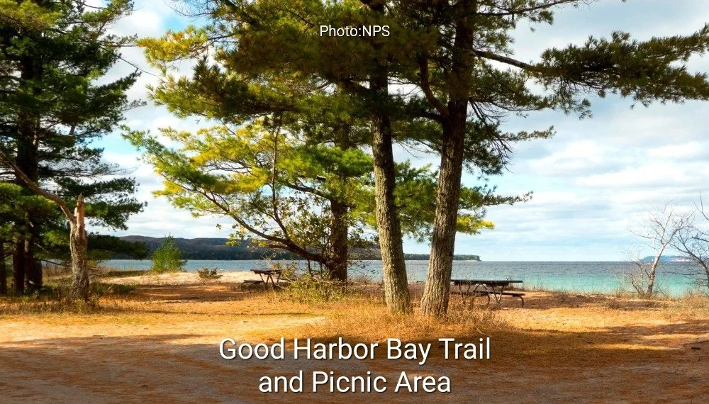
Mansfield have recommended in their report a Heritage Walking Trail loop that utilizes existing paths and trails (map). It would be a non-bicycle path. The Good Harbor Bay Trail is a hiking path that begins at the picnic area at the eastern end of Lake Michigan Road. This is a loop that connects to the west end of Traverse Lake Road. Further east there is an old roadbed that runs north and then turns east, locally known as Swanson Trail / Juniper Trail. It is only a short walk from both of these existing trails to access Lake Michigan, and people frequently walk along the beach, completing a loop. Or a hiking trail can follow the old roadway that went along the shore between the east end of Lake Michigan Road and Juniper Trail. Swanson Trail and Juniper Trails were both leveled a few years ago by NPS so dump trucks could remove building material from the houses that used to be on Lake Michigan. Both of these trails are in the Wilderness Area.
Mansfield recommends building a narrow low-impact walking trail (5-6’ wide for two people to walk side by side or pass, using natural material, NOT as substantial as the Pyramid Point Trail photo), meandering around trees from the west end curve of Traverse Lake Road and proceeding east along the staked Segment 9 route to the Swanson / Juniper Trail. This new walking path would connect the two existing trails. Walking along Lake Michigan would complete the loop if a hiking trail was not established. Access could be created at Cleveland Township Park which has parking, restrooms and a picnic area. The main trailhead is at the Good Harbor Trail picnic area to the east end of Lake Michigan Drive which has parking and restroom facilities. Trail funds could be used to improve and upgrade the facilities at Cleveland Township Park and to improve roadside parking at the two locations along Traverse Lake Road that are currently used by people to park and walk.
Create special opportunities to experience nature
The alternative of Heritage Walking Trail that connects existing trails fits the recreational purpose of the Heritage Trail as well. The Heritage Trail goal is to expand recreational opportunities, which should not be limited to all forms of recreation having to happen on just one type of trail. Creating the opportunity to walk, run, hike and ski on a Heritage Walking Trail connecting with other existing trails would be a great addition to the Heritage Trail. This trail could also be used for non-groomed cross-county skiing or snowshoeing in the winter.
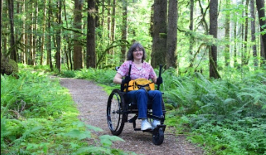
The new walking trail along Traverse Lake Road could still meet all accessibility requirements (wheelchairs) with a low impact improved path, as well as the existing Swanson Trail / Juniper Trail which has also been recently graded and should regularly be kept clear of fallen debris for those with disabilities. The Good Harbor Bay Trail loop would not meet accessibility requirements unless improved (west trail portion of loop worthy of consideration). There are few opportunities for users with disabilities to enjoy nature with Sleeping Bear Dunes National Lakeshore without having to go on asphalt paths. If one desires an improved paved path, there are 22 miles of options along the existing Heritage Trail. Mechanical forms of transportation, such as bicycles, are not allowed in the Wilderness Area but wheelchairs are.
This alternative would avoid the sensitive and vulnerable environmental areas and avoid introducing new traffic corridors into the most sensitive wooded dune and swale complexes. It would utilize low-impact construction methods (bobcat skid loader) with minimal trail width requiring far less tree removal; it could more easily meander around the more sizeable trees, unlike bulldozing a 25’ width path to construct an asphalt path. This new trail would be about 1.5 miles in length and tie into existing walking paths. There would be minimal cost in comparison. Mansfield estimates a cost savings of $14+ million.
Facilitate a wilderness hiking trail along staked Segment 9 route
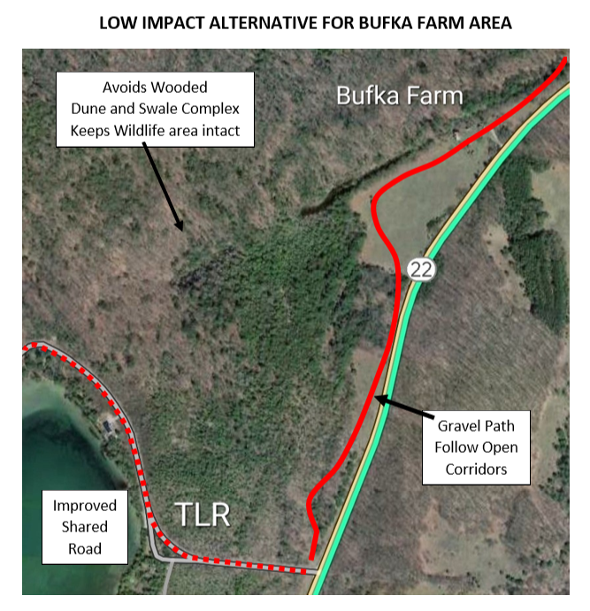
Mansfield also suggests the current staked route in the Bufka area from Traverse Lake Road north to Good Harbor Trail would be best suited for a no-impact wilderness hiking trail for visitors to enjoy the beauty of globally rare (less than 80 occurrences) and State Concern wooded dune and swale complexes. The old growth cedars are stunning and the pristine wetlands are unique and should be experienced in the beauty of an unaltered state. The route of the Bufka wilderness hiking trail could be delineated by using the fallen trees to line the path. There would be many educational opportunities to educate visitors about the many environmental features along the way. Trailhead parking would be at the Bufka farmstead.
It is time to design trails to fit the natural environment - not just the route but also the type of recreational trail that minimizes impact on sensitive and vulnerable ecosystems. There are 22 miles of the existing Heritage Trail as options for paved recreational opportunities for bicyclists. This Heritage Walking Trail would be a great way to create diverse opportunities that still meet all the goals within the 2009 Leelanau Scenic Heritage Route Trailway Plan & Environmental Assessment.


Access Good Harbor via CR 669 and Lake Michigan Road
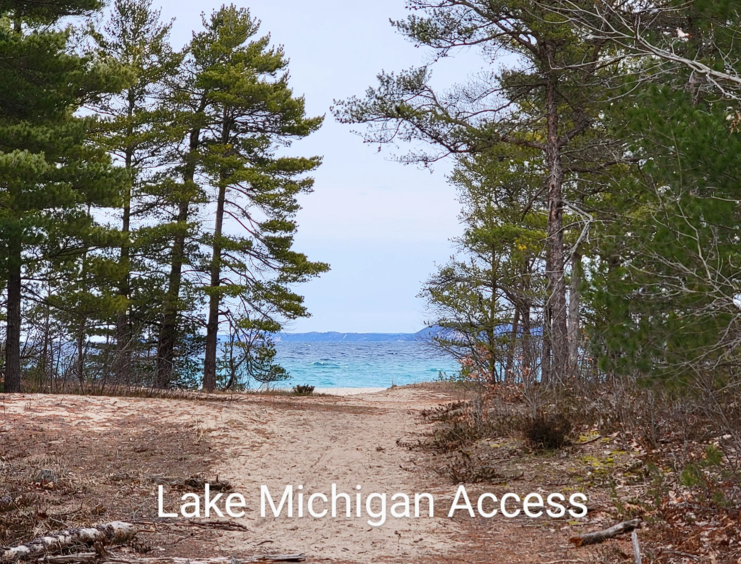
The main feature for visitors and users to experience the Good Harbor area is not a path along Traverse Lake Road but rather accessing the viewshed of the Good Harbor Bay to enjoy the sights and sounds of Lake Michigan. Nowhere else along the entire Heritage Trail do users have that amazing opportunity, except in Glen Haven. The pristine sandy beaches and sparkling waters of Lake Michigan are among the most important attractions in the Lakeshore. The Leelanau blues of a sunny sky blending into Lake Michigan are amazing.
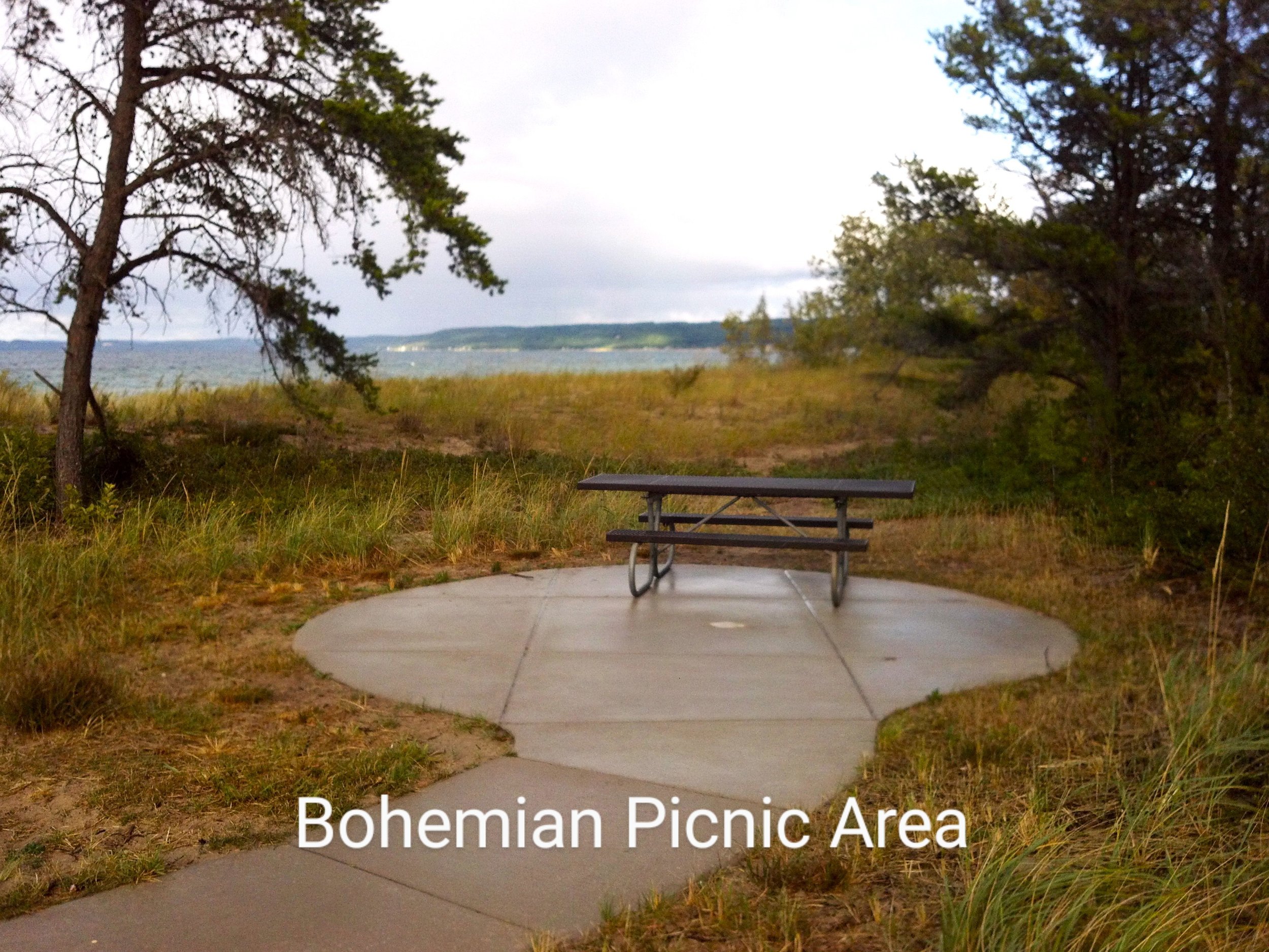
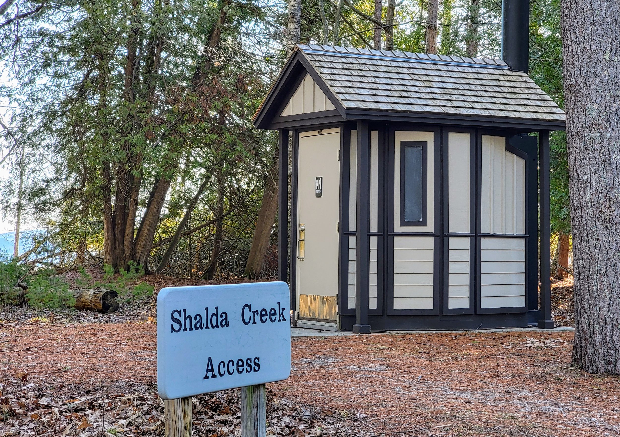
Mansfield studied an alternative to Segment 9 that utilizes Bohemian Road / CR 669 and Lake Michigan Road to access Good Harbor Bay (map). The trail would extend north from the intersection of M-22 and Bohemian Road / CR 669 near the Cleveland Township Hall where the Heritage Trail currently ends. The trail would run north to Bohemian Beach and then east and west along Lake Michigan Road & Good Harbor Bay Drive, incorporating many features that already exist along the path: Good Harbor Bay Picnic Area at the east end, base of Pyramid Point on the west end of Good Harbor Drive, facilities midway at Shalda Creek crossing area, a beautiful winding 0.5 mile county road access to Shell Lake which is exempt from the wilderness area for bicyclists to use, and other access points to the beach within the designated recreational zone along Lake Michigan Road. This area is highlighted in both NPS General Management Plan and Cleveland Township Master Plan as a priority for recreational enhancement.
Mansfield analyzed building an off-road trail in the county road right-of-way which is already cleared along the 1.25-mile Bohemian Road / CR 669 corridor. This would require minimal permitting since it is within the road right-of-way with fewer environmental features. Approximately 1,550’ of elevated boardwalk is required across wetlands, including crossing Shalda Creek. The power lines would be relocated underground to enhance the natural scenic beauty along Bohemian Rd / CR 669 and provide room for trail construction without having to remove more trees. If TART Trails and NPS are suggesting that landowner approval is not required for a trail going across private property, then an off-road trail in the county road right-of-way along Bohemian Road / CR 669 would not need NPS approval, even though NPS is the only property owner.
Mansfield also suggest Lake Michigan Road and Good Harbor Drive could be used to add an additional 3.5 miles of recreational opportunities by creating a multi-use shared path that could be paved with extra shoulder width and innovative shared road design. It certainly merits exploring how a path could be designed. Both of these roads are low-volume, dead-end, non-connector roads.
As part of facilitating connecting access to features within the Lakeshore, Mansfield proposes improving the 0.5 mile county road access to Shell Lake by improving the gravel base of this narrow public road.
Alternative saves thousands of trees and millions of dollars
This alternative would have little environmental impact, if any. It does avoid removing 7,300 trees. It avoids all the protected, regulated, sensitive, and vulnerable areas along Segment 9 while still creating recreational opportunities. There are no vulnerable wooded dune and swale complexes or State-protected Critical Dune Areas. Bohemian Beach would serve as a Heritage trailhead with existing parking, restroom facilities, and picnic areas. It avoids the congested Good Harbor Beach at the end of Good Harbor Trail / CR 651, which has insufficient parking during the summer. It also avoids all private property. The Mansfield report estimates a cost savings of $10 million while still creating an additional 4.75 miles of recreational opportunities.
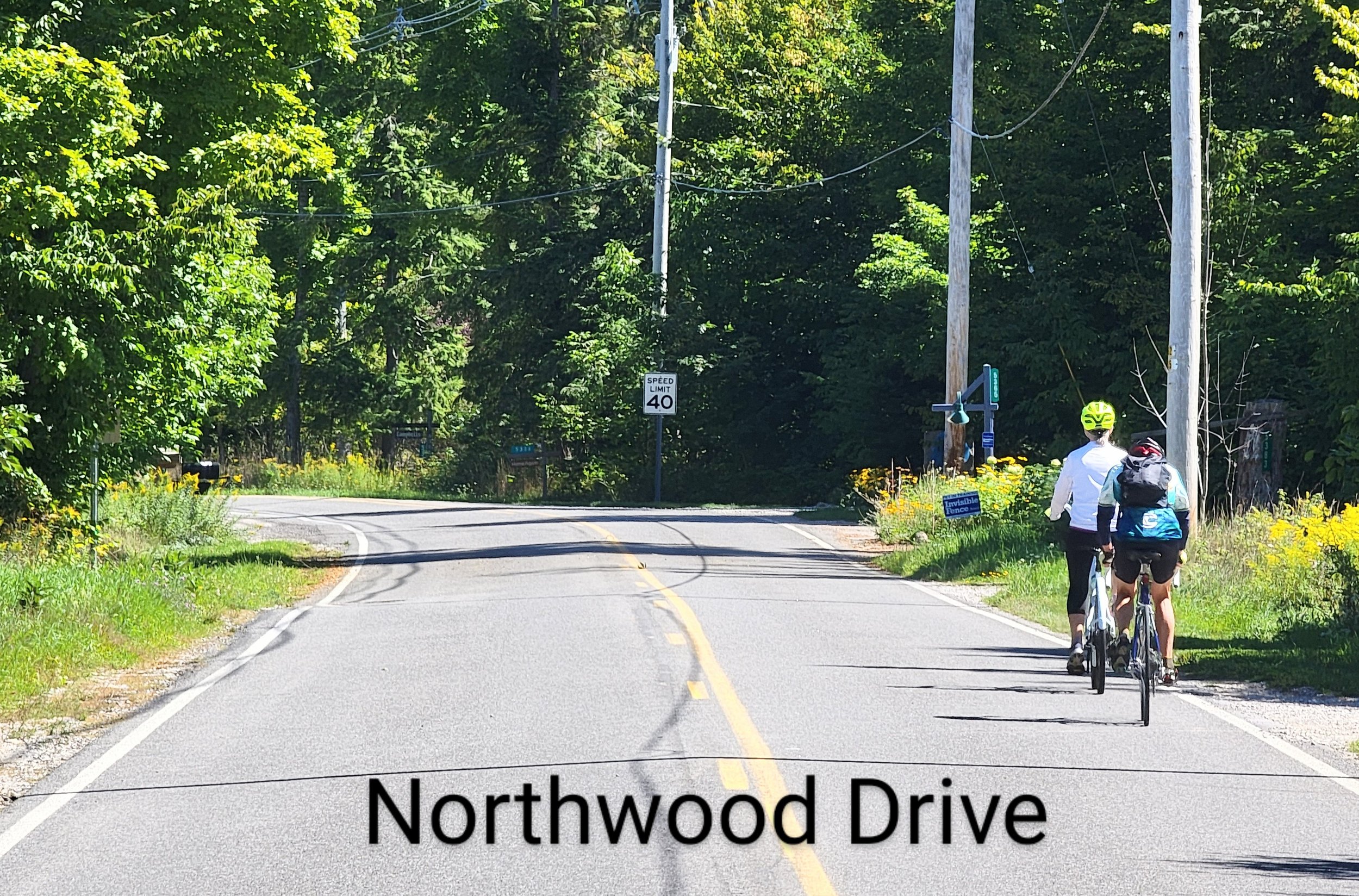
The Heritage Trail uses four shared roads as part of its existing trail routing: Northwood Drive along Glen Lake, Lacore Road near Empire, Forest Haven Drive near Glen Arbor and Pine Haven Drive accessing D.H. Day Campground. Good Harbor Trail / CR 651 is proposed to be a shared-use road as part of Segment 9 to access over-capacity parking at the beach. So this proposed alternative would follow that precedent.
Cleveland Township has unanimously recommended this as the preferred alternative in the past. TART Trails has indicated support for a trail along Bohemian Road / CR 669. NPS identifies it as a potential trail in the future on the Heritage Trail map. LCRC has no concerns with a separated path in the road right-of-way. Why not complete this trail now with its simplicity of design as a low cost trail with minimal impact to the environment? Accessing Good Harbor Bay at Bohemian Beach would be the crown jewel of the Heritage Trail and serve as a stunning trailhead.

Video of Bohemian Road - CR 669 and Good Harbor Boy area


Reconsidering the M-22 Alternative
NPS originally proposed two alternatives in 2008, one of those being an off-road trail along the north side of M-22 from Bohemian Road / CR 669 eastward to Good Harbor Trail / CR 651. The preferred option became a shared road use of Traverse Lake Road (TLR) due to its lower impact. The north side of M-22 has 41 driveways serving residential structures, which are closer to the road edge, and also has various wetlands and muck soils closer to the west and east TLR intersections.
When the trail got moved off-road along TLR, the environmental assessment comparison, if actually and accurately completed, would have shown the M-22 alternative as having significantly less environmental impact, making it the preferred alternative. NPS did not fully evaluate and explore M-22 options, certainly not in comparison to the significant environmental impact and engineering designs that would be needed with the new proposed Segment 9 off-road trail along M-22. The errors and omissions in the environmental assessment did not allow the community to make informed decisions or to accurately comment. An M-22 alternative could be built for $5 million, a cost savings of nearly $10 million since extensive wetland boardwalks and massive dune retaining walls would not need to be built.
Exploring options along the south side of M-22
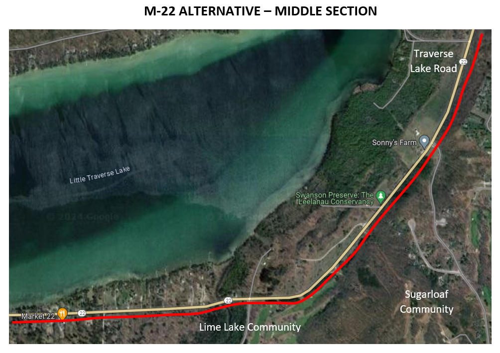
Mansfield suggests reconsidering the M-22 alternative, but as a separated trail within the State M-22 right-of-way along the south side, rather than the north side (see map). This would truly serve a transportation purpose allowing people to access goods and services. The M-22 alternative would provide access to three businesses: Market 22, Traverse Lake Inn, and Good Harbor Gallery. It would provide the residents in this area, including Sugarloaf and Lime Lake Communities, with easier non-vehicular access to the Heritage Trail and Lake Michigan rather than riding down a busy M-22 Highway. The M-22 route option would provide a transportation purpose with a greater benefit to more local people than an off-road recreational trail through the wilderness along Traverse Lake Road.
The northern portion of this M-22 alternative would create a beautiful experience allowing the user to enjoy the scenic farm meadows along the east side of M-22. These meadows are part of the Sleeping Bear National Lakeshore and are currently underutilized and not fully appreciated by visitors This route would create a detour from the sights and sounds of M-22 and would end with a parking lot trailhead near Overby Road at the northern boundary of the Lakeshore, avoiding all the problems with proposed Segment 9 ending at Good Harbor Trail / M-22 and over-capacity parking challenges. It would be a superior experience than what is being proposed in the Bufka Farm area, without users encountering extensive boardwalks and massive retaining walls. The open viewsheds in the meadow areas would be inspiring as well. Construction designs would be more typical and less extensive without crossing wetlands. As a result, Mansfield estimates the cost for the total 5.0 miles would be $5.5 million, $10 million less than the $14.5 million proposed Segment 9 route.
There are fewer environmental features as compared to the north side of M-22 even though an elevated boardwalk would be required for 350’ across Shetland Creek. It avoids the challenges associated with the Bufka Farm area, including the steep ravines close to M-22 on the west side. Tree removal is required between Sugar Loaf property and Townline Road, with two 300’ sections of 5’ retaining wall due to slopes, but the trail could possibly be offset farther so as to maintain the scenic M-22 tree canopy and provide the user with a more natural wooded experience along the trail. This route is not within the State protected Critical Dune Area, unlike 85% of the proposed Segment 9 trail.
While a trail can be created along M-22 highway within the State right-of-way, there are impacts to private property along the way. There are 27 driveways and the private structures are farther back from the road on the south side. Those owners should be engaged in the conversation as to the impacts and safety concerns during the conceptual phase, not just in the construction stage. It cannot be presumed that creating a trail across private property, even in the right-of-way is acceptable. Due to safety concerns with the high-speed and high-volume M-22 Highway, property owners might enjoy an off-road sidewalk and separated access to the Heritage Trail or Lake Michigan as a trade off. The shoulder on the north side of M-22 between West Traverse Lake Road and Bohemian Road could be widened to 10 feet, providing a safer travel corridor for non-vehicular travelers headed west.
It is important to consider that there is NO private property along Bohemian Road / CR 669 and Lake Michigan Drive. That is a preferred alternative for the Heritage Trail in this Good Harbor region due to its low or no impact to private property, among other reasons.
While not a goal of NPS or the Lakeshore’s mission, TART Trails has publicly mentioned the concept of connecting to the Suttons Bay and the Leelanau Trail. There has been no community engagement on that bigger concept, where a connector trail should go or the purpose. It may not be something the local community thinks is necessary. That should really be figured out first besides just extending the Heritage Trail for the sake of extending the Heritage Trail. If the trail was to be extended north from Good Harbor Trail to M-204, there are 11 driveways servicing structures on east side (“south”), including Good Harbor Winery, and 75 driveways on the west side (“north”) of M-22. So routing a trail along the south (east) side of M-22 would make sense in terms of any potential future planning, IF M-22 is to be used as a connector.
There are other routes within Leelanau County that might also make sense besides continuing east and north along M-22. These routes could connect other communities and business centers in Leelanau County. A connecting trail could instead go south on Bohemian Road / CR 669 through Lakeshore property until intersecting with CR 616, then head east on CR 616 through Maple City and onward to Cedar. Then the trail route could go through the heart of the beautiful farm country to Lake Leelanau and Suttons Bay. This could also be an identified scenic bike route with addition of 5-7’ shoulders to the existing roads.


Modify proposed Segment 9 route as a lower impact alternative
Another option presented in the Mansfield report follows the general proposed Segment 9 route but avoids the significant environmental impact. It is a preferred alternative to the proposed Segment 9 route due to the avoidance of vulnerable ecosystems and wilderness along Traverse Lake Road and in the Bufka Farm area, resulting in cost savings of well over $10 million.
The Mansfield report proposes using Traverse Lake Road (TLR) as a shared road path, not used as-is but with road modifications adding safety designs, such as lowering the speed limit, widening the paved surface, incorporating traffic calming measures, increasing sight distance around curves, and exploring innovative shared use design while tailoring the designs to address specific characteristics of TLR. The Michigan legislature passed HB-4012 in March 2024 which allows local units of government to lower speed limits on county roads to the fiftieth percentile. It could be possible to lower the speed limit on Traverse Lake Road from 40 mph to 35 mph, or perhaps less. That is a new option that was not available previously.
Traffic counts by Leelanau County Road Commission (LCRC) in 2018 found that TLR is a low-volume, non-connector road with less than 100 cars per day and an 85th percentile speed of 37 mph. Rarely do two oncoming cars meet simultaneously on this local non-connecting county road. LCRC has indicated that Traverse Lake Road is not suitable for a shared road as-is, although many road cyclists currently use it as part of their ride during the summer and local residents use the road currently for walking, running and biking.
The alternative lower impact Segment 9 route (map) would still utilize the current routing alongside M-22 from Bohemian Road / CR 669 to west Traverse Lake Road. It still would significantly impact the residential residence on the corner. The alternative route would follow TLR to the east intersection with M-22 as an improved share road, modified to address safety concerns. From there, the trail would meander north along M-22 through open corridors and farm field to Bufka Farm, without requiring significant tree removal or traversing the wooded dune and swale complex between TLR and Bufka Farm. The trail would then follow M-22 within 25 feet of the white line avoiding the globally rare and State concern wooded dune and swale complexes further to the west of M-22..
Mansfield estimates cost savings of $10.5 million, even with including in the budget funds to replace the Shalda Creek TLR culvert as part of road improvements. The Mansfield report provides additional engineering perspectives related to lowering the speed limit below 35 mph, adding 2’ shoulders, exploring low impact options to increase sight distance, incorporating traffic calming features such as speed tables in locations near curves, and then consider innovative share road designs that communities are now using with more common frequency. These designs have been shown to reduce speeds, lower accidents, increase safety and have good user experience over time.
This alternative route avoids the regulated wetlands with a State Special Concern Species on the west end of TLR, the forested dune along TLR, the steep Critical Dune Area that requires significant retaining wall construction, and the vulnerable wooded dune and swale complexes between TLR and CR 651, leaving the ecosystem intact with its old growth cedar swamp. In 2008, NPS determined there was “0” impact to their proposal of using TLR as-is as a shared road. Unfortunately, no one has looked in-depth as to how TLR could be improved and modified to enhance the safety experience for all users.
The downside is that it still does not alter Segment 9’s plan to stop the trail at the intersection of Good Harbor Trail and M-22, requiring users to use Good Harbor Trail to access the beach. This area is already facing congestion problems with insufficient parking during the summer and cars parking along the roadside towards M-22. And it is limited in not providing users additional opportunities to enjoy other Lake Michigan features in this Good Harbor area as would Bohemian Road / CR 669 access.

A comprehensive approach
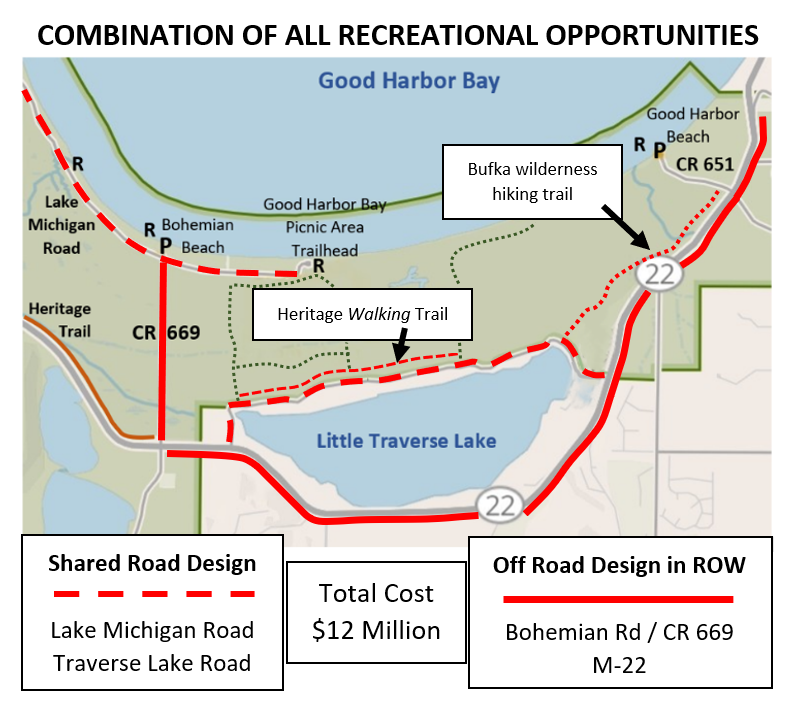
Mansfield suggests that it is time to consider a more comprehensive approach to creating recreational opportunities in this Good Harbor region. NPS and TART Trails seemed entrenched in a narrow scope of defending a line on the map that was drawn 15 years ago. What if the community and all stakeholders looked at the bigger picture of what could be achieved with $14.5 million in a more cost-efficient design approach? Maybe this is not about determining winners and losers but being able to complete a comprehensive approach for the entire Segment 9 Good Harbor region benefitting a greater number of people. Mansfield estimates that ALL of the alternatives combined could be built for just over $11 million, resulting in a savings of $3 million compared (see map) to the proposed $14.5 million 4.25 mile Segment 9 trail. ALL of these alternatives could create a comprehensive approach to recreational opportunities in this Good Harbor area:
A 1.5 mile low impact, non-intrusive Heritage Walking Trail using the staked route along Traverse Lake Road for people to enjoy the full natural experience while running, walking, skiing, or using wheelchairs. Complete upgrades to restroom facilities at Cleveland Township Park. Minimal tree removal, no wetlands, no dune hills. Convert the proposed Segment 9 route in the Bufka Farm area between TLR and Good Harbor Trail into a no-impact wilderness hiking trail. Cost: $135,040
Modifications and design improvements to the 2.4-mile Traverse Lake Road, including $700K matching funds to replace the Shalda Creek culvert, to improve safety for shared use. No environmental alterations. Cost: $1,323,592
A 1.3-mile off-road trail in the county right-of-way along Bohemian Road / CR 669 north to Good Harbor Bay; paved improvements and a shared road design along the seasonal 3.5-mile Lake Michigan Road; gravel improvements to the 0.5-mile Shell Lake county road access. Shalda Creek stream crossing required along Bohemian Road / CR 669 but no other environmental impact within the cleared right-of-way. Cost: $4,171,620
A separated 5.5 mile off-road trail within the State right-of-way along the south (east) side of M-22 from CR 669 to a parking trailhead near Overby Road, beyond CR 651. Provides transportation access to local goods and services and provides an exceptional user experience in the Lakeshore’s farm meadow area. Shetland Creek stream crossing required but no other wetlands and outside of State protected Critical Dune Area. Cost: $5,501,900
TIMING, PROCESS AND SHARED LEADERSHIP CONSIDERATIONS
All of these improvements are within the right-of-way of a State highway or county roads, except the Heritage Walking Trail and the off-road trail through farm meadows east of M-22 which are on NPS property. NPS approval is not required nor would the federal project requirements apply for modifications with the right-of-way (Bohemian Road, Lake Michigan Road, Traverse Lake Road, M-22). These could be projects led by Cleveland Township as a community initiative in partnership with State of Michigan, Leelanau County Road Commission, and TART Trails continuing as funding partner. NPS does have an important role to play and should be involved in the discussions but does not have to be project owner for all of these alternatives. NPS could focus on the section of off-road trail along the east side of M-22 on Lakeshore property from Traverse Lake Road to Overby Road as well as the walking trail. The permit process would be less complicated by avoiding all the vulnerable ecosystems and sensitive environmental features and with easier engineering designs. A botanical study would be less extensive within a road right-of-way and the design process might include fewer complicated engineering considerations.
Further professional evaluation of these options could be completed by summer 2024, including a botanical survey identifying environmental features and a preliminary engineering analysis identifying key design features along the route and any engineering requirements. Community input could be facilitated during the summer, including a survey of local residents. If there is broad community buy-in, then engineering could be completed by December 2024. Multiple engineering firms under the oversight of MDOT and LCRC sharing design responsibilities for different alternatives. Permits could be obtained during winter 2025, construction started Spring 2025, and completed by fall 2025. The timeline would be no different than the proposed Segment 9 with all of its extreme engineering design features that take extra time and cost to permit and build.
What is the urgent rush and why the push for the proposed Segment 9 at the expense of not allowing community input and feedback? Taking a pause and allowing the community to explore a more comprehensive approach to this Good Harbor region is worth the time and effort. That discussion has NOT been allowed by NPS or TART Trails in the last fifteen years. The only discussion that seems to be acceptable is about one line on the map, and even that discussion has been extremely limited and narrow. There is no time urgency to build this trail. This is a non-essential recreational luxury that has permanent environmental impacts lasting for generations. It is time to have a bigger community discussion on creating recreational opportunities in this Good Harbor area within Cleveland Township.

Usage of shared roads along the existing Heritage Trail
Currently four roads are used as a shared roadway for portions of the existing Heritage Trail: Northwood Drive along the north shore of Glen Lake, Forest Haven Drive serving as a connector from Glen Arbor to the trail segment below Alligator Hill, Pine Haven Drive that accesses D.H. Day Campground, and Lacore Road north of Empire (which has 5’ shoulders on the county road portion). These roads are currently used by bicyclists and walkers. There is a precedent in creating shared road access.
It seems wise to invest some time, energy and research into finding ways to improve shared roads and create a better and safer user experience for all. The answer is not always found in paving a separate asphalt path. If substantial cost savings result from utilizing other options for Segment 9, those funds could be used to improve these shared access roads, including widening or adopting innovative shared use designs. Funds could also be used to improve parking and perhaps add more restroom facilities along the existing Heritage Trail.


Various shoulder designs
There are several shoulder designs that all meet AASHTO (American Association of State Highway and Transportation) safety requirements in designing multi-use roads and accommodating non-vehicular users. The minimum shoulder width is 5’ shoulders (e.g. Lacore Road), but road agencies can increase the width. In the vicinity of Cedar, CR 651 has 7.5’ shoulders and other roads (M-204) in Michigan have as wide as 10’ paved shoulders. There are many options for shared road designs that meet safety standards. And road cyclists can and do legally use roads as is without any shoulders, but there are many options to improve safety.


Consider Vail’s experience - $12 million in savings

The Mansfield report mentions communities that have been implementing innovative designs to create safe multi-use roads used by bicyclists, walkers and vehicular drivers. One such community is Vail, Colorado. Vail was looking for a way to connect two off-road trails similar to the Heritage Trail. The $12 million plan hit a roadblock with significant environmental challenges, private property impacts, increasing cost prohibitions, and concerns raised by local residents. Instead, Vail Valley Drive was converted into a multi-use facility using an innovative design that accommodates two-way vehicular traffic and provides wide shared space for non-vehicular users. The community saved $12 million, had zero impact on the environment and the connector road is now successfully used by 1200 bicyclists, 250 walkers and 400 vehicles (and 10 city buses) per day during peak summer usage with high user satisfaction. None of the roads as part of the Heritage Trail or those in the Good Harbor area have anywhere near this volume of user. The Vail video can also be found via this link (Town of Vail).
Edge Lane Roads repurpose the existing road by creating space for walkers and bikers as well as accommodating vehicle traffic. The design includes a 10’ center drive lane and two dashed edge lanes. Research has shown vehicular speeds decrease and safety increases as compared to traditional road designs. This innovative shared road design has been used by more than 90 communities in the U.S. and has been safely used in Europe since 1970. Communities have used innovative shared road designs with existing road widths (such as Vail Valley Drive). Additional non-vehicular user space can be created when the road is widened on each side to create even wider edge lanes (7’ wide edge lanes with adding 2’ to road on each side, 10’ wide edge lanes with adding 5’ to road on each side). For more information on the design, visit Edge Lane Roads.
Obviously the community of Vail got together to think outside the box and found a win-win solution for the environment, for non-vehicular users, and for drivers. That is the result of a healthy community conversation and people’s willingness to listen, think and work together.
CONSIDER THE EXPERIENCE OF YARMOUTH, MAINE
The town of Yarmouth, Maine, was one of the first communities to implement Edge Lane Road design in New England. The design worked so well they now have 9 roads with Edge Lane Road design, including the use on a major bridge crossing a large river. The community has found that walkers and bikers like the experience while drivers have slowed down and modified their behavior, The end result is improving safety while creating a space on the road for all users. The roads in Yarmouth are very similar to the shared roads that are part of the Heritage Trail route. It would be a feasible application to other roads like Lake Michigan Drive and TLR. The Yarmouth video can also be found via this link (Bicycle Coalition of Maine).
Video of Vail’s experience with Edge Lane Road design
Video of Yarmouth’s experience with Edge Lane Road design


Are we afraid to consider alternatives?
The public has more access to information now than ever before, and it should have access to even more. A botanical survey has actually been done in the field along the staked and flagged route, and thus we have a better understanding today of the sensitivity and vulnerability of ecosystems than fifteen years ago. The public is gaining more understanding about the extreme design features that are needed for construction, which were not disclosed fifteen years ago. Cost is becoming more important as a consideration. Actual user volume further away from Glen Arbor is low compared to what was projected fifteen years ago. We should always update our environment-cost-benefit analysis.
Times have changed too. Climate change and the role of our environment are becoming more important for future generations. What seemed like a good idea fifteen years ago doesn’t mean it’s the best decision for tomorrow, let alone today.
Why are we afraid to consider alternatives? Why are we sometimes afraid to process new information? Why are we sometimes reluctant to change course to create something that might be a win-win, even if it doesn’t look the way we thought it would? The proposed route for Segment 9 was a line drawn on a map in 2009. Fifteen years have gone by. There certainly is the ability to change if we are open-minded. Why should decision-makers be afraid to have an idea from fifteen years ago be scrutinized? Why are certain discussions or ideas considered off limits, including what are other alternatives that could create great recreational opportunities in the Good Harbor region? Why is the proposed Segment 9 the only option, if it is even open to discussion? Why is public feedback limited to only being able to discuss how one patriarch tree can be saved or what material we want a retaining wall to look like?
Sometimes the way trails have been built in the past is not the only way to create recreational opportunities in the future or in the present. Trails are an important part of our community, allowing opportunities for non-vehicular modes of recreation. The trail movement began by converting railroad beds into trails. Then communities found opportunities where trail systems could be easily created other than by using railroad beds. But communities are now looking at other ways to create recreational opportunities without the high cost or environmental impact of only building off-road paved trails. Alternatives can be explored and many can be experimented with first due to their less permanent impact. Just because one can build a trail across any environment, regardless of the costs involved, doesn’t mean that is what should be done. The end goal doesn’t always justify the means. There is a bigger picture we need to see. Bulldozing and paving a trail is a permanent decision that alters natural states well into the future.
Not all options and alternatives have been fully explored for the Good Harbor area. Certainly no comparison of environmental impacts have been publicly disclosed. NPS and TART have decided those important discussions are off limits. Why?
Choose alternatives that are supported by all stakeholders
Sometimes heroes are those being open-minded enough to find win-win solutions: where nature and humanity win and where trail advocates, environmentalists and community members can arrive at better alternatives. Current stakeholders include: NPS, Tart Trails, Leelanau County Road Commission, MDOT, Cleveland Township, the the general public, local community, trail users, and the environment itself. Are there alternatives that would result in support from all stakeholders? It seems like all stakeholders might support a Heritage Walking Trail and creating more recreational opportunities along Bohemian Road / CR 669 and Lake Michigan Road. These would be win-win-win options. Not all stakeholders are in support of the proposed Segment 9. Even a lower impact alternative for Segment 9 may not be supported by all stakeholders. Why would alternatives not be considered that have greater stakeholder support, including the general public?
The idea of looking at other ways to access Good Harbor Bay has been proposed by many over the years, including Cleveland Township. NPS and TART Trails have repeatedly shut down conversations about exploring the idea of using CR 669 / Lake Michigan Road as a Segment 9 alternative. “Not on the table. Maybe in the future.” Why is that? Why not have that conversation now? Are they afraid it might make more sense to the general public and members of the local community? Is NPS afraid they may have not fully explored all the alternatives to access Good Harbor Bay as required by the National Environmental Protection Act? Is TART Trails afraid their one goal of getting to Suttons Bay may have to be thought out more fully? It is long overdue for a bigger conversation. This illustration was found on https://www.alongtheshore.info/
