“Away, away, from men and towns, To the wild wood and the downs, To the silent wilderness, Where the soul I need not repress its music.” - Percy Bysshe Shelley
Botanical survey documents environmental impact

Segment 9 has the most sensitive ecosystems of the existing 22-mile Heritage Trail. An independent botanical survey, “Pathway to Good Harbor: Heritage Trail Segment 9 Tree Survey,” commissioned by Little Traverse Lake Association (LTLA), was completed by Borealis Consulting LLC. This is the first time a professional and detailed botanical survey has ever been done. The route was staked by OHM Consultants in May 2023. The credentialed botanist walked the entire 4.25 mile route and completed an inventory of all trees within the 25’ trail construction path and also identified the various ecosystems. According to LTLA, “Since we were not able to answer those questions from what has been published to date, the Association took on the task of inventorying the trees and species along the Segment 9 path.”
The survey findings are summarized below with links provided to full copy of report. There is no portion, except perhaps the short segment along M-22 from Bohemian Road to Traverse Lake Road, that is not a vulnerable ecosystem protected or regulated by the State or that has special environmental concern from a state or global perspective. Segment 9 has the most sensitive ecosystems of the existing 22-mile Heritage Trail.

Video of Dune Forest along proposed Segment 9 Heritage Trail
Mature wooded dune forest - 7,300 trees removed
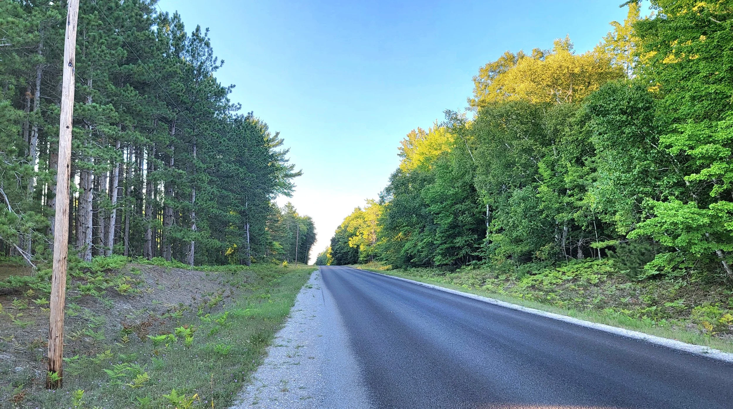
The botanical survey identified 7,300 trees that would be removed during the construction process of the proposed Segment 9 Heritage Trail. Nearly two miles of the trail, about half the route, cuts through a mature mesic northern forest along the north side of Traverse Lake Road. This area is classified and protected as a Critical Dune Area by the State of Michigan.
The 7,300 trees are part of a healthy ecosystem that has a diversity of tree species as well as the range of trees from saplings to mature patriarchs that are normally part of a forest ecosystem. The most common species of all stems are American beech (20%), sugar maple (15%), white pine (12%), red oak (10%), ironwood (8%) and eastern hemlock (8%). There are 4,258 trees larger than 4” diameter with 284 larger than 20” in diameter. The smaller trees and saplings are mostly beech trees regenerating in the forest as older beech trees die off due to disease. Beech only make up 20% of the species and the natural process allows for them to be replaced by other species as part of a healthy ecosystem.
NPS and Tart Trails have stated their intent to avoid the largest trees in final trail routing. The difficulty is that when one tree is avoided, other trees nearby in the forest are then taken out instead. The path still clears a 25’ wide path through a mature and healthy forest ecosystem. It sounds admirable to swerve the trail but practically it’s still bulldozing the forest to save a tree.
Trees and vegetation contribute to carbon sequestration. Protecting these areas helps mitigate climate change by maintaining natural carbon sinks that absorb and store atmospheric carbon dioxide, which is becoming a more important function of undisturbed ecosystems. The lack of tree canopy along the new open path also creates additional impacts to the species makeup of the ecosystem with removal of shade, allowing invasive species to grow as they take root in the excavated construction swath. The open corridor invites new bird populations (like crows) that become competitors to songbirds. The open trail path also allows sunlight to heat the 10’ wide asphalt path.
The wooded dune forest along Traverse Lake Road was not identified in the NPS 2009 Trailway Plan & Environmental Assessment and an impact score of “0” was assigned to vegetation, despite 7,300 trees to be removed.

Ecological and Floristic Assessment of Good Harbor Bay Wooded Dune and Swale Complex
In October 2024, National Parks Conservation Association (NPCA) contracted with Orbis Environmental Consulting (lead investigator botanist and vegetation ecologist Brad Slaughter) to report the findings of an ecological and floristic assessment of a wooded dune and swale complex bordering Good Harbor Bay in Sleeping Bear Dunes National Lakeshore (SBDNL), Leelanau County, Michigan that included the Burfka Farm area through which Segment 9 is routed. A copy of an excerpt summary can be found here and a copy of the full report can be found here.
Wooded dune and swale complex is unusual among the 77 natural community types defined by Michigan Natural Features Inventory (MFNI) in that it encompasses both upland and wetland habitats and an array of plant associations. The study area consists of a wooded dune and swale complex that includes examples of at least seven other natural community types—dry-mesic northern forest, Great Lakes barrens, interdunal wetland, mesic northern forest, open dunes, rich conifer swamp, and sand/gravel beach.
Over 400 vascular plant species were documented from this complex, including the federally and state threatened Cirsium pitcheri (Pitcher’s thistle), state threatened Pterospora andromedea (pine-drops), and state special concern Cypripedium arietinum (ram’s-head lady-slipper). The state special concern Berula erecta (water-parsnip) was recently documented in a tributary of Shalda Creek just outside the study area [on private land].
Among the 411 vascular plant species identified during the 2024 field surveys, at least 84 (20.4%) were identified as culturally sensitive species by members of the Grand Traverse Band of Odawa and Chippewa Indians. Uses of these species can range from medicinal, ceremonial, and subsistence to creating baskets for gathering. Three Odawa tribes—Grand Traverse Band of Ottawa and Chippewa Indians, Little Traverse Bay Band of Odawa Indians, and Little River Band of Ottawa Indians—are culturally affiliated with Sleeping Bear Dunes National Lakeshore.
The study area is affected by numerous stressors, including human recreation, invasive plants, animals, and pathogens, chronically high water levels associated with beaver activity, high levels of deer browse, and misapplication of prescribed fire. The report identifies several management policy considerations to ensure the protection of the rare and vulnerable ecosystem.
Some of the report’s conclusions include:
The wooded dune and swale complex at Good Harbor Bay is of state and global significance, worthy of special management policy considerations to ensure its longterm environmental integrity. Its inclusion within SBDNL should afford this vulnerable ecosystem maximum protection in a mostly unaltered and unfragmented state.
Most of the study area [is] included within the SBDNL Wilderness Area designation. However, a wedge-shaped area of approximately 77 acres located east and north of E Traverse Lake Road and extending to M-22 that was originally proposed [in the adopted 2008 SBDNL General Management Plan] for inclusion was ultimately excluded. Consideration should be given to amending the SBDNL Wilderness Area to include the entire excluded area to maintain connectivity between the rich conifer swamp and the rest of the wooded dune and swale complex and promote restoration of the cleared uplands.
Maintaining [the integrity and quality of this wooded dune and swale complex] will require the implementation of sound conservation and management practices following the principal of primum non nocere ("first, do no harm"). At a minimum, this would involve restricting the use of prescribed fire to appropriate habitats and avoiding construction of any new trails or roadways that would fragment critical habitats and foster the spread of invasive species.
The [Good Harbor] study area is a good-to-fair example of wooded dune and swale complex, a vulnerable (S3) natural community in Michigan. SBDNL has an opportunity to showcase the vulnerable wooded dune and swale complex at Good Harbor Bay by highlighting the significance of the habitat and its component biota and educating the public as to its environmental significance while allowing visitors to enjoy the ecosystem in its natural unaltered state.


Video of wooded dune and swale complex north of Bufka Farm
Vulnerable Wooded Dune & Swale Complex fragmentation


A significant portion of the trail, located in the Bufka Farm area between Traverse Lake Road and CR 651, is routed 1.5 miles through a sensitive ecosystem known as wooded dune and swale complex, made up of alternating upland dune ridges and wetland swales. These are globally rare, vulnerable ecosystems of State Concern that are identified for protection from intrusion and fragmentation. This is an area that currently has very little human traffic, other than deer hunters, and is currently unfragmented and in its natural state. The wetlands are in a pristine state with no invasive species. A PDF summary of wooded and dune swale complexes can be found here.
The independent botanical survey completed by Borealis Consulting stated:
“Wooded dune and swale complex is the second largest community impacted by the Pathway to Good Harbor … Wooded dune and swale complex is made up of parallel, alternating wetland swales and upland dune ridges formed by receding water levels post-glaciation, and is considered a dune formation. Section 4 of the Pathway to Good Harbor route follows the edge of the Critical Dune Area as mapped (see Fig. 3), however, during field surveys Section 4 was found to be entirely within the wooded dune and swale complex natural community and the trail follows dune swales in part”.
Wooded dune and swale complexes are typically rich in biodiversity. This particular wooded dune and swale complex in the Bufka area features majestic old growth white-cedar trees with eastern hemlock comprising 19% of the tree species. They provide habitat for a variety of plant and animal species, some of which may be specially adapted to the specific conditions of these environments. The Borealis report cites the significance of this sensitive ecosystem:
“Wooded dune and swale complex is ranked as Vulnerable at the State and Global level due to a restricted range, relatively few occurrences (often 80 or fewer), recent and widespread declines, or other factors making it vulnerable to extirpation (Faber-Langendoen et. al. 2012). Wooded dune and swale communities are declining in size and condition due to residential and recreational development and accompanying road building, causing disrupted hydrological conditions, wetland destruction, nutrient loading, and the introduction of invasive species (Cohen et. al. 2020).”
Michigan State University, which manages Michigan’s Natural Heritage Database, recommends the following biodiversity management principles when describing the significance of wooded dune and swale complex:
“Residential and recreational development and accompanying road building in and around wooded dune and swale complexes has resulted in disrupted hydrological conditions, wetland destruction, nutrient loading, and the introduction of invasive species. Conservation efforts should focus on protecting wooded dune and swale complexes from development and fragmentation, preserving natural hydrology, and controlling invasive species. Because of the wide diversity of habitats provided by wooded dune and swale complexes, invasive species that threaten the diversity and community structure include species from all ends of the moisture and light continuums.”
Michigan Department of Natural Resources identifies wooded dune and swale complex as a priority for protection and the avoidance of fragmentation. In an effort to protect these complexes in the Upper Peninsula, MDNR stated in the Lake Michigan Wooded Dune and Swale ERA Plan:
“Wooded dune and swale complexes are threatened in various ways. Habitat fragmentation, hydrologic disruption, wetland filling, nutrient loading and invasive species introductions occur from roads, rail grades, utilities, and shoreline development. In some locations, there is intense recreational use including excessive foot traffic, mountain bike trails and ATV use. Because of the wide diversity of habitats provided by wooded dune and swale complexes, invasive plants {that} threaten the diversity and community structure include species from all ends of the moisture and light continuums.
Many wooded dune and swale complexes harbor rare and endangered species that are specially adapted to the coastal environment. Protecting these habitats is crucial for the survival of these species, contributing to global biodiversity, conservation efforts. and overall ecosystem health. The Borealis botanical survey notes:
“State Threatened pine-drops are known to occur in the wooded dune and swale complex and forested dunes along Good Harbor Bay (Section 3 and 4; MNFI 2023, Michigan Flora Online 2011). No observations of pine drops were made during the survey. Pine-drops are protected under the Endangered and Threatened Species Act of Michigan, Part 365. This rules that “a person shall not take, possess, transport, import, export, process, sell, offer for sale, buy, or offer to buy, and a common or contract carrier shall not transport or receive for shipment, any species of fish, plants, or wildlife appearing on the Threatened and Endangered Species List.” Destruction of a plant or its habitat constitutes a taking. Permits may be issued to remove, capture, or destroy a threatened or endangered species to alleviate damage to property or to protect human health.”
The vulnerable dune and swale complex between Traverse Lake Road and Bufka Farm, and the adjoining rich conifer swamp extending towards M-22, is prime wildlife habitat with the mixture of upland dunes and lower wetlands. This area was originally planned to be included in the proposed Wilderness Area and identified as such in the 2008 General Management Plan for Sleeping Bear Dunes National Lakeshore. The proposed Wilderness Area boundary was changed prior to passage of the legislation in 2014 to accommodate the routing of Segment 9 of the Heritage Trail as proposed in 2009. The trail should have been routed around the proposed wilderness area identified in the 2008 General Management Plan, not the Wilderness Area boundary altered to match the Segment 9 trail route. This area is identified as an environmental priority, low recreational impact area in the 2008 NPS General Management Plan. These globally rare wooded dune and swale complexes that are of State concern but were not identified in the 2009 NPS Trailway Plan and Environmental Assessment, nor was the fact that 85% of the trail length was in the State Critical Dune Area.
Nearly 20% of Segment 9 requires elevated boardwalks to be built through regulated wetlands, including those that are part of wooded dune and swale complexes. Trail construction requires clearing of trees, brush and vegetation that is in the way of building boardwalks. Much of the wetland areas in the Bufka Farm area are wooded and significant tree removal is required, creating an open corridor without the natural tree canopy. The proposed boardwalk sections are intrusions into natural areas that are currently untouched by human traffic. The boardwalk also creates a barrier to wildlife movement and fragments the vulnerable ecosystem. The open corridor can remove shade protection and open the wetlands up to invasive species.
Construction of boardwalks through wetlands requires using heavy duty equipment to drill piers into mucky wet soil for many feet, even as much as 20’ based on soil composition and depth, with heavy-duty drilling equipment. It is a significant challenge getting heavy construction equipment into the wooded dune and swale complex due to the remote wilderness location with the only access being from Traverse Lake Road, Good Harbor Trail or Bufka Farmstead due to steep topography and extensive wetlands in this area.
The construction process creates a long-lasting impact and cannot be restored to its pristine condition. During the March 23, 2024 Cleveland Township Annual Meeting, Krista Phillips, MDOT project manager for Heritage Trail design, commented about the construction designs in the wooded dune and swale complexes in the Bufka Farm area:
“Back in the undeveloped land that is hard to construct, we are still figuring out how to construct the trail. A lot of area it’s a choice between wetland and dune. Are we going to put more retaining walls to hold back the dune or are we going to board walk over the wetlands. It’s so beautiful back there. A lot of areas it’s a challenge to figure out how to get a paver back there. How are we going to get a large excavator to drive the piles in to build the boardwalk? So we still have to answer some of those questions. Even though the plan is to restore wetlands back to its original condition, we are disturbing wetlands. The type of disturbance and restoration, even though its a boardwalk and the wetland can restore, we are still going to plan to mitigate it and buy wetland credits elsewhere because of the disturbance in the wetland area.”
It is not acceptable to significantly impact and alter wetlands in this globally rare and State Concern wooded dune and swale complex by simply buying wetland credits to expand wetlands in another state. This vulnerable ecosystem is beautiful and should be fully experienced and appreciated in their undisturbed natural state. Just because it can be designed on paper, doesn’t mean it should be built in nature. There are trail routing options to avoid intrusion into natural areas, especially into the sensitive and vulnerable wooded dune and swale complex. Those alternatives are feasible, low impact and less expensive, allowing globally rare and State Concern wooded dune and swales to remain unfragmented and experienced in its natural condition.


Video of State protected Critical Dune Area along Segment 9 Heritage Trail

85% of trail routed through State protected Critical Dune Area
According to the credentialed botanist, 85% of the trail route is located within the State protected Critical Dune Area. A PDF summary of Critical Dune Area can be found here. The Michigan Legislature enacted Part 353 Sand Dunes Protection and Management as part of the Natural Resources and Environmental Protection Act 451 of 1994 to protect Michigan’s critical dune areas. As part of the state law, “The legislature finds that: (a) The critical dune areas of this state are a unique, irreplaceable, and fragile resource that provide significant recreational, economic, scientific, geological, scenic, botanical, educational, agricultural, and ecological benefits to the people of this state and to people from other states and countries who visit this resource” (324.35302 Legislative findings, Sec. 35302). Earthmoving, vegetation removal, and construction activities are prohibited within Critical Dunes and regulated through a permit process” (botanical survey report). The State-protected Critical Dune Area of Segment 9 Heritage Trail was not identified in the 2009 NPS Trailway Plan & Environmental Assessment.
Steep State-protected Critical Dunes come down to the edge of Traverse Lake Road at the east end. Construction requires the clearing of trees to the top of the dunes and removal of a significant portion of this State-protected Critical Dune Area before large retaining walls are built. Mansfield states in their engineering analysis report:
“Based on our field measurements, LCRC design requirements, OSHA safety requirements, and generally accepted design practices, our staff concludes that construction of the trail through the State regulated Critical Dune Area along east Traverse Lake Road requires building retaining walls for 950’ that can be 25’ or more in height. A multi-tiered design for the retaining walls would extend the height up to 37’ in height. This height is greater than a 2.5 story house.”
The removal of trees and construction of retaining walls with a southern exposure will result in additional warming along the trail during the summer. Trees act as natural sound barriers, absorbing and deflecting noise. Without tree canopy and the construction of large retaining walls, traffic sounds will increase. This is a scenic wilderness road immediately adjacent to the protected Wilderness Area with the trees providing beauty and a shade canopy. This is not a suburban area but a scenic wilderness area.
Critical Dune Areas in Michigan are characterized by unique ecosystems, including sand dunes, interdunal wetlands, and associated plant and animal communities. These ecosystems often harbor rare and specialized species that are adapted to the unique conditions of sand dunes. Some of these species may be specially adapted to the sandy soils and harsh conditions of the dunes, and protecting their habitats is crucial for their survival. Protecting these areas also contributes to broader climate change adaptation efforts.
The State-protected Critical Dune Area was not identified in the NPS 2009 Trailway Plan & Environmental Assessment and a score of “0” was assigned to the impact on topography.

Video of wetlands along proposed Segment 9 Heritage Trail
Nearly 20% of the proposed Segment 9 Heritage Trail crosses regulated wetlands and will require construction of elevated boardwalks after clearing of vegetation. The trail runs through a rich conifer swamp along the west end of Traverse Lake Road. This is a State-regulated wetland because it is larger than five acres and is connected to surface water. This wetland ecosystem is also the habitat for a population of cut-leaf water parsnip, a State Special Concern Species that was downgraded in 2023 from State Threatened.
“State Special Concern identifies this species as a ‘…declining or relict species in the state. While not protected by law, these species need protection to prevent them from becoming Threatened or Endangered’ (MNFI 2023). Though the population was not mapped within the ROW [population exists 15’ from the trail route], impacts to canopy cover, hydrology, and invasive species are a concern and measures should be taken to minimize disturbances … invasive species may impact cut-leaf water parsnip, especially if the canopy is opened.” (survey report)
This regulated wetland along Traverse Lake Road was not identified in the NPS 2009 Trailway Plan & Environmental Assessment and thus assigned a score of “0” impact to wetlands since the existence was not noted. The State Special Concern species was also not identified as a botanical survey was not completed as part of the NPS Environmental Assessment. The construction of elevated boardwalks in this area was not included in the itemized cost projections.
Rich conifer swamp with State Special Concern species

Shalda Creek water basin
The trail route crosses Shalda Creek and thus a bridge will need to be built or incorporated as part of a new concrete box culvert that includes the roadbed. The Leelanau County Road Commission has identified the need to replace the road steel culvert and it is in their upcoming work plan. The creek is very wide at the point of trail crossing and may be wider than a box culvert can span since the creek cannot be filled in or altered. In that case, a new wood bridge will be needed to span Shalda Creek. This stream crossing was not identified as part of the 2009 NPS Trailway Plan & Environmental Assessment for Segment 9 nor was there mention of a bridge in the itemized cost projects for Segment 9.

Rare species & invasive Species
A population of State Special Concern Species cut-leaf water parsnip was found 15’ from the proposed trail route in the rich conifer wetlands. “State Threatened pine-drops are known to occur in the wooded dune and swale complex and forested dunes along Good Harbor Bay (Section 3 and 4; MNFI 2023, Michigan Flora Online 2011). No observations of pine-drops were made during the survey. Pine-drops are protected under the Endangered and Threatened Species Act of Michigan, Part 365. This rules that ‘a person shall not take, possess, transport, import, export, process, sell, offer for sale, buy, or offer to buy, and a common or contract carrier shall not transport or receive for shipment, any species of fish, plants, or wildlife appearing on the Threatened and Endangered Species List.’ Destruction of a plant or its habitat constitutes a taking. Permits may be issued to remove, capture, or destroy a threatened or endangered species to alleviate damage to property or to protect human health.” (survey report)
“Invasive species were relatively sparse, particularly in the forested dune and wooded dune and swale complex. …. Trail creation is likely to create new invasive species risks. Trails have been well-established as vectors for invasive species (e.g. Anderson et al 2015) through several mechanisms. Tree removal, depending on the extent, can cause edge effects in forests (more light, higher temperatures). This, combined with soil surface disturbance created by trail construction, creates favorable seed germination sites for early successional, ruderal, and invasive species. Movement along the trail moves invasive species seeds down the trail to new germination sites via treads on shoes and tires, hitchhikers on clothing, etc. An emerging invasive species, slender false-brome (Brachypodium sylvaticum), has been found spreading along the Heritage Trail (and other areas) since its installation in Critical Dune Area between the Dune Climb and Glen Haven, and is of particular concern. Himalayan blackberry (Rubus bifrons), another emerging invasive species in Michigan, has also been observed spreading in forest openings in Leelanau County and is along the trail near Glen Haven. Though this is animal-dispersed, it may take advantage of newly created germination sites and should be monitored.” (survey report)

A trail at Sleeping Bear Dunes National Lakeshore has been closed for 2024 due to concerns over an invasive species infestation of hemlock woolly adelgid. According to the National Park Service, the invasive species can kill a hemlock tree in as little as four years by accessing the tree’s nutrients at the base of the needles, starving the tree. The Borealis botanical survey identified trails as one of the main contributors to the spreading of invasive species with increased human traffic. The Good Harbor area is home to some of the oldest old-growth hemlock stands, including close to the proposed Segment 9 route. According to the Borealis botanical survey, 8% of the 7,300 trees (584 trees) to be removed are eastern hemlock. Constructing Segment 9 as a new corridor into wilderness areas could introduce an infestation of invasive species that would have a devastating impact on the natural undisturbed ecosystem.
No survey has been done to determine whether the Northern long-eared bat, which was added to the endangered species list effective January 30, 2023, is within the project area.


Introducing a new asphalt path and trail corridor into wilderness areas would create disruptions to local wildlife. The trail section from Traverse Lake Road north to the Bufka Farm and beyond to Good Harbor Trail / M-22 transects and fragments a significant wildlife habitat area that currently has very few human interactions and minimal usage other than occasional hunters. The proposed Segment 9 Heritage Trail route would introduce new human activity in a wilderness area that is presently undisturbed. It is a wilderness area that is home to many different wildlife species. This is one of the prime habitats for deer due to the rich conifer swamp converging with the upland dune forest. The trail would interrupt that natural wildlife habitat pattern. The introduction of a new human transportation corridor can impede the movement of wildlife, leading to isolation of populations and potential impacts on biodiversity.
Unlike wilderness hikers able to enjoy wildlife in a more natural state, bicyclists on an asphalt path rarely encounter wildlife in natural patterns. Increased human activity associated with paved trails can disturb wildlife, particularly sensitive species. Noise, vibrations, and the presence of people may lead to changes in animal behavior, potentially affecting reproduction, feeding, and migration patterns. Bicycles can move at higher speeds than hikers, potentially causing more noise and disturbance as they pass through an area. The sudden and rapid movement may startle wildlife, leading to disruptions in their behavior. Wildlife may have less time to habituate to the presence of a fast-moving bicyclist. Habituation is the process by which animals become accustomed to the presence of humans and adjust their behavior accordingly.
Impact to wildlife
Comparison to Alternative Route
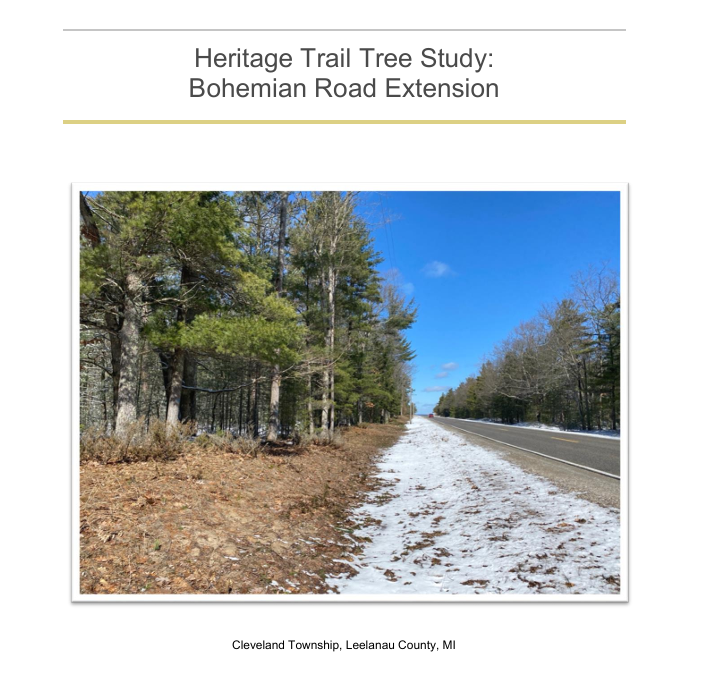
An alternative pathway to Good Harbor Bay has been supported by Cleveland Township and other stakeholder groups, including Sleeping Bear Naturally. This alternative route would access Good Harbor Bay at Bohemian Beach with a Heritage Trail route extending north along the Bohemian Road / CR 669 right-of-way, identified by NPS as a "proposed route for future study" on maps. A botanical survey of this proposed route was completed by Borealis Consulting LLC and a copy of the report, "Heritage Trail Tree Study: Bohemian Road Extension," can be found here. The botanical survey identified 50 trees in the 1.2 mile long ROW on the west side. Of those 50 trees, 38 were saplings, 10 were small trees 3.9 - 9.8", and 2 trees were larger than 9.8" in diameter. Accessing Good Harbor Bay via the Bohemian Road alternative would require 7,250 trees fewer trees to be removed than accessing Good Harbor Bay via Segment 9 route. NEPA requires NPS to consider alternatives with less environmental impact, especially when the route reaches the same Good Harbor Bay. Botanist Liana May included this finding in the report:
While the surrounding natural communities are ecologically significant and some areas are subject to regulation, the ROW presents an area that is already subject to disturbance with minimal native vegetation, thus may have a relatively lesser impact to trees and native vegetation than a trail constructed through other areas, such as interior forest.