“Just because you can, doesn’t mean you should.”


Engineering analysis reveals extreme construction designs
An independent analysis of the proposed Segment 9 Sleeping Bear Heritage Trail design elements was conducted by Traverse CIty-based engineering firm Mansfield Land Use Consultants. This firm conducted field measurements and applied standard construction design requirements for identifying possible Segment 9 Heritage Trail designs. Mansfield conducted a dune cut analysis of what the potential engineering design might entail, in addition to cost evaluation of Segment 9, environmental impacts of construction designs, and possible construction alternatives for creating recreational opportunities in the Good Harbor region of the Sleeping Bear Dunes National Lakeshore. The purpose of the independent analysis was to give the public greater information and understanding of the potential design elements in Segment 9, since those designs have not been revealed.
Even after fifteen years, the public still does not have any information of various design elements that are part of the proposed route and what the construction entails. For example, as of last year, neither the National Park Service, TART Trails nor Michigan Department of Transportation knew what would be involved in constructing the trail through the large and steep State-protected Critical Dune Area along Traverse Lake Road, including being able to inform the public of how high up the Critical Dunes the trees would need to be cleared or how high the retaining walls would need to be (Little Traverse Lake Association August 2023 presentation). MDOT is in the process of working on engineering designs with final plans completed by the summer of 2024. If significant construction design elements are not completed and released to the public until 2024, how then could the impacts have been fully evaluated fifteen years ago in 2009 when NPS determined the Environmental assessment?
The Mansfield report contains a significant amount of information pertinent to the proposed Segment 9 as well as creating recreational opportunities in the Good Harbor region that demonstrate environmental stewardship, design flexibility and financial feasibility. The report, “Engineering Design Analysis of Recreational Opportunities in the Good Harbor Region,” can be found here. The summary of findings and recommendations are on page 57-58.

Typical trail construction - 25’ clearing width
Typical trail construction, based on historical practices and confirmed by MDOT and TART Trails during an August 2023 presentation to Little Traverse Lake Association, includes first clearing a swath 25’ feet wide that is free of trees, brush and vegetation. Next the topsoil is excavated and graded, questionable subsoil material removed, and the swath cut deep to remove tree roots. Then a layer of sand is brought in followed by a layer of gravel. A 10’ wide asphalt layer is then laid down and 2’ gravel shoulders added on each side for a finished trail width of 14’. The remaining area is graded and seeded.


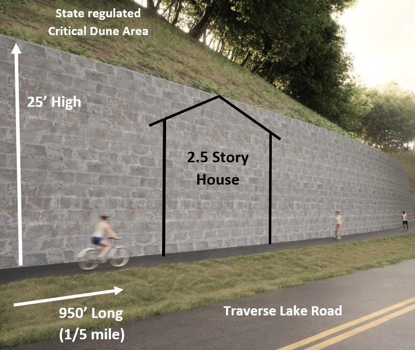
Massive 25’ high retaining walls required
Segment 9 is routed through State protected Critical Dune Area for 85% of trail length. The most significant impact section are the large and steep Critical Dunes that extend down to the road edge of east Traverse Lake Road. Trail construction requires significant tree clearing to near the top of dunes, removing trees from the road all the way 100’ to the border of the Wilderness Area. Once the Critical Dunes are cleared of all vegetation, trail construction requires a removal of a significant portion of the Critical Dune itself with transport to a land fill area. OSHA requires cutting back the slope to a 1:1 grade to the bottom of the retaining wall for safety reasons during construction. After the Critical Dune material is hauled off-site, construction of massive retaining walls can commence. The final step is then paving of the 10’ asphalt path with 2’ safety shoulders.
After completing their analysis of what is required for retaining wall construction, the Mansfield report concludes:
“Based on our field measurements, LCRC design requirements, OSHA safety requirements, and generally accepted design practices, our staff concludes that construction of the trail through the State regulated Critical Dune Area along east Traverse Lake Road requires building retaining walls for 950’ (nearly 1/5 mile) that can be 25’ or more in height. A multi-tiered design for the retaining walls would extend the height up to 37’ in height. This height is greater than a 2.5 story house.”
A copy of the Mansfield construction cross sections can be found here. Construction of these massive retaining walls requires a permit from the Leelanau County Road Commission (LCRC) for use of the road right-of-way and a permit from the Michigan Department of Environment, Great Lakes and Energy (EGLE) for construction in a State protected Critical Dune Area. Is this the new urban look for our rural neighborhood roads through a scenic wilderness area in “America’s Most Beautiful Place?”
It is an understatement to say that the scenic character of this beautiful wilderness road will be forever altered to a permanent urban feel. The tree canopy will be removed and the massive retaining walls will increase the heat signature and will bounce road noise back to the local residents. That’s not even mentioning the complete decimation of the State regulated Critical Dune Area that borders the Wilderness Area of the Sleeping Bear National Lakeshore. It is beyond imagination as to why NPS and TART Trails believes this is even acceptable trail planning. The end does not justify the means.
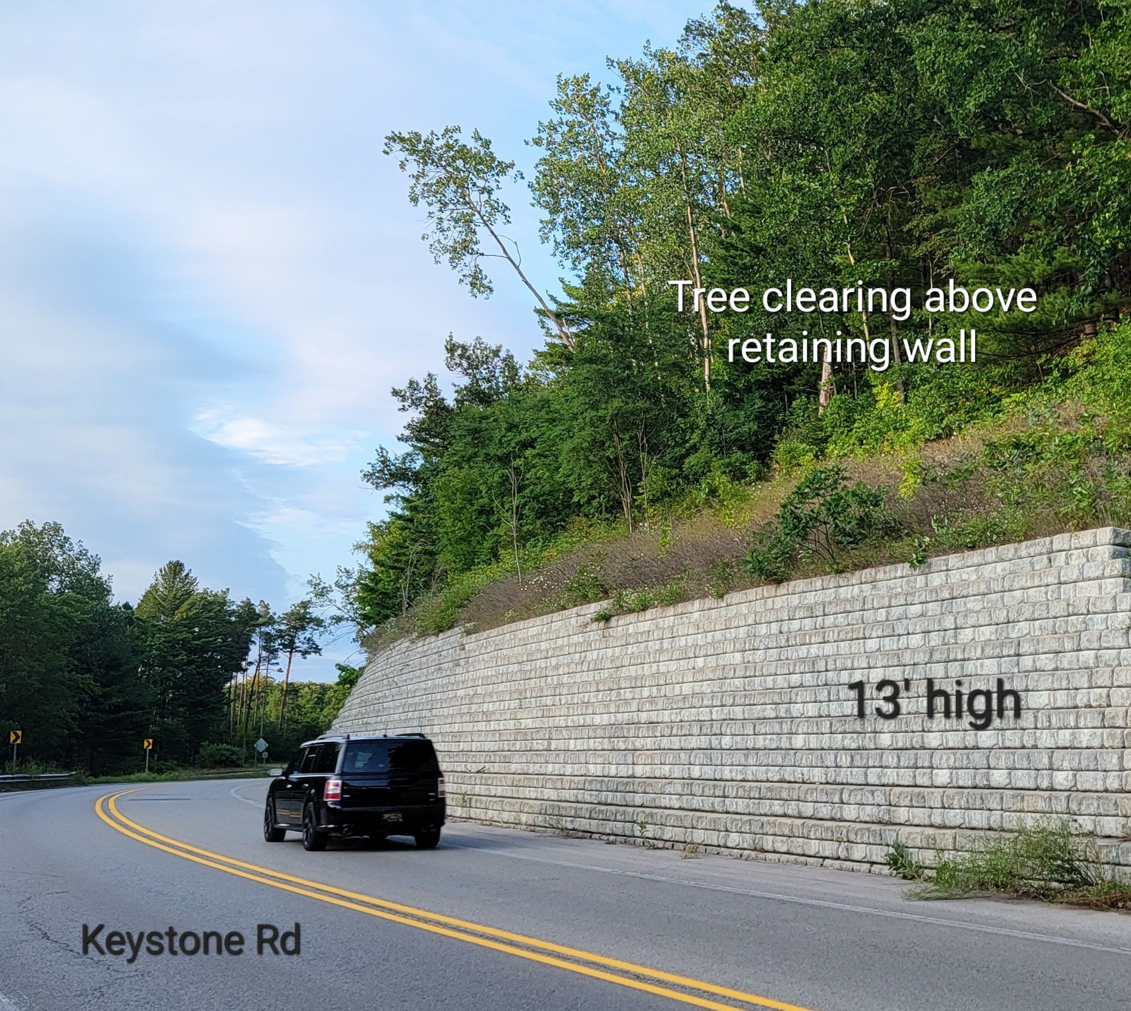
A couple of local examples of large retaining walls is a 24’ high wall west of Best Buy in Traverse City and a 13’ high retaining wall along Keystone Road in Traverse City. Keep in mind, retaining walls along Traverse Lake Road can be 25’ or more in height, equivalent in size to a 2.5 story house.


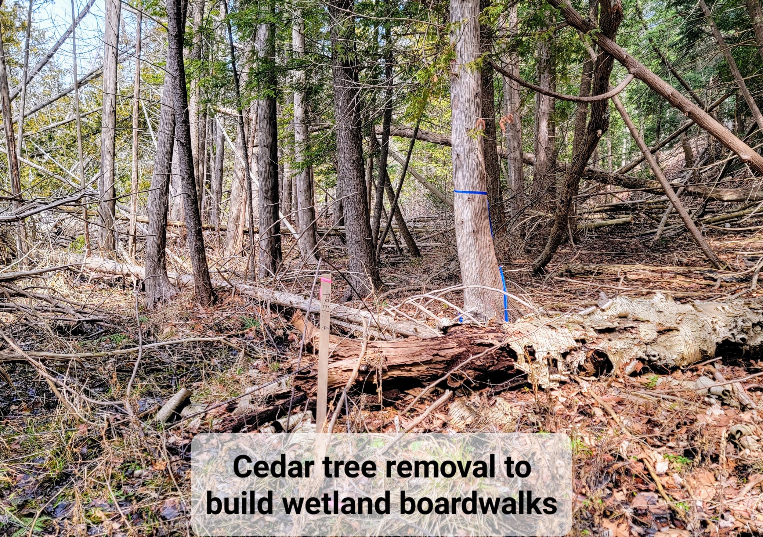

Elevated boardwalk required for nearly 20% of trail length
Construction of elevated boardwalks requires a permit from the Michigan Department of Environment, Great Lakes and Energy (EGLE) and a permit from Leelanau County Road Commission (LCRC) for constructing the boardwalks in the county road right-of-way. During the March 23, 2024 Cleveland Township Annual Meeting, Krista Phillips, MDOT project manager for Heritage Trail design, commented about the wooded dune and swale complexes in the Bufka Farm area:
“Back in the undeveloped land that is hard to construct, we are still figuring out how to construct the trail. A lot of area it’s a choice between wetland and dune. Are we going to put more retaining walls to hold back the dune or are we going to board walk over the wetlands. It’s so beautiful back there. A lot of areas its a challenge to figure out how to get a paver back there. How are we going to get a large excavator to drive the piles in to build the boardwalk? So we still have to answer some of those questions. Even though the plan is to restore wetlands back to its original condition, we are disturbing wetlands. The type of disturbance and restoration, even though its a boardwalk and the wetland can restore, we are still going to plan to mitigate it and buy wetland credits elsewhere because of the disturbance in the wetland area.”
When there are only destructive and expensive choices for trail construction, it is time to ask, “Why are we building this asphalt trail back in the wilderness?”
According to MDOT, 18% of the proposed Segment 9 Heritage Trail is through regulated wetlands that require elevated boardwalk construction. While it may seem a normal part of trail construction, it certainly increases construction costs significantly and requires ongoing maintenance and replacement at some point in the future. The extent of boardwalk construction was not identified in the NPS 2009 Trailway Plan & Environmental Assessment and was not figured into the itemized cost projection for Segment 9.
But these are not your typical wetlands. The rich conifer wetlands at west Traverse Lake Road (TLR) are host to a population of State Special Concern species. The wetlands between TLR and Bufka Farm and beyond to Good Harbor Trail / CR651 are part of globally rare (only 80 occurrences) and state concern wooded dune and swale complex. Trail construction requires clearing of trees, brush and vegetation that is in the way of building boardwalks, introducing human traffic to a sensitive and vulnerable ecosystems which are unfragmented by human impact. Pilings to support boardwalks will need to be driven 15-30’ or more based on soil conditions into these fragile wetlands. There are feasible route options to avoid the intrusion into undisturbed natural areas.

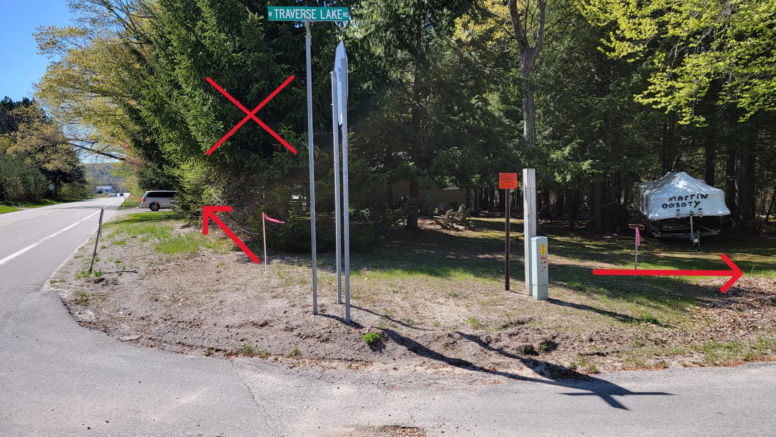
Relocation of west end of Traverse Lake Road
MDOT, which is overseeing trail design work, revealed during a presentation at the Little Traverse Lake Association August 2003 annual meeting that there will be a relocation of the west end intersection of Traverse Lake Road (TLR) and M-22, moving TLR over 10’ to the east and tapering the relocation back 400’ to accommodate a wider turn radius for the proposed Heritage Trail. This road relocation and reconstruction will be an added expense that was not previously included in the original budget as an item needed for construction of the proposed Segment 9 route. Relocating Traverse Lake Road requires approval from the Leelanau County Road Commission.
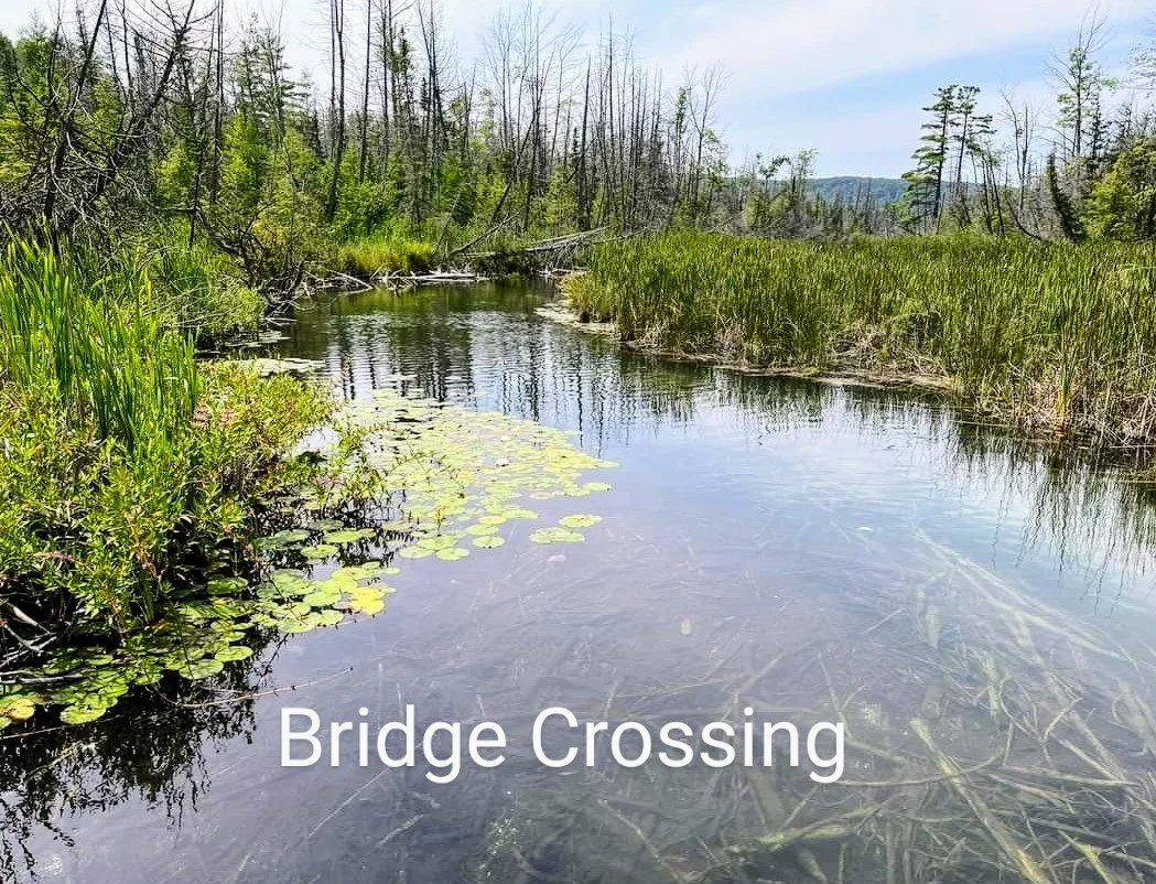

Shalda Creek bridge crossing
The proposed off-road Segment 9 Heritage Trail routing along west Traverse Lake Road (TLR) requires the construction of a bridge to cross Shalda Creek. Shalda Creek immediately widens at the outlet side of TLR culvert This crossing would be a separate wooden bridge or an extension of the roadway by replacing the existing culvert structure with a new box culvert design that is wide enough to accommodate TLR as well as the 10’ trail width plus safety accommodations.
This new box culvert bridge could be more than 45’ in width (TLR width 20’ plus 5’ shoulders plus 10’ trail width with 2’ shoulder space). Since the creek immediately widens at the culvert outlet, and since it cannot be filled in, there is a question about culvert design: whether a box culvert can span the large width from bank to bank. Thus, it is likely that a bridge span would be required. Cost would be over $1 million for a simple box culvert design. Design of this crossing is still not known and requires a permit from Michigan Department of Environment, Great Lakes and Energy (EGLE), which will need to evaluate the impact of a new culvert / bridge design on Little Traverse Lake hydrology, and approval from the Leelanau County Road Commission (LCRC).
This bridge was not identified or included in the budget for Segment 9 as presented in the 2009 NPS Trailway Plan and Environmental Assessment.


Removal of scenic tree canopy near road edge
Segment 9 of the Heritage Trail is routed in many places close to the road edge along M-22 and on the east end of Traverse Lake Road due to right-of-way limitations across private property or due to topography challenges with steep State protected Critical Dunes forcing the trail closer to the road. The trail design is required to maintain a 10’ safety separation from road edge to the 10’ paved asphalt path along with 2’ gravel shoulders so typically 23’ from road edge is cleared. As a result, tree removal is required, significantly impacting the scenic tree canopy that hangs over the road which provides shade as well as beauty during summer and the fall color season. A permit is required from the Leelanau County Road Commission (LCRC) for constructing the trail within the county road right-of-way.

Segment 9 Heritage Trail is routed across five private properties using the road right-of-way. Usage of the road right way for construction of a third party trail requires a permit from MDOT and Leelanau County Road Commission (LCRC). The residence at the corner of M-22 and west Traverse Lake Road will see the greatest impact. The trail will be within 10 feet of their residential structures, eliminate parking in front of their garage, and also remove a row of evergreens that provides a vegetative privacy screen for their yard and firepit area. The trail also crosses the front yards close to other residences and also removes mature trees in their front yards. Another aspect is safety and liability when backing out of their driveways.
These types of trail impacts seem to be dismissed as only “a few property owners” who are labelled as NIMBYs (Not In My Back Yard). Maybe the concerns are legitimate. How would we feel if that was us living there? What will happen when TART Trails plans to extend the trail to Suttons Bay which entails private property the entire way? Perhaps trails should be designed as if the designer is the person living there as a resident.
Close proximity to private property
Video of proposed Segment 9 Heritage Trail impacts on private property
Permit approvals required for construction
A permit is required from Michigan Department of Environment, Great Lakes, and Energy (EGLE) to construct boardwalks (20% of trail length) across regulated wetlands, including those part of the globally rare and State Concern wooded dune and swale complexes and those with a population of State Special Concern species within 15’ of proposed trail. EGLE has a 30 day public comment period and a formal public hearing if requested. A permit is also required from EGLE for trail construction through the State protected Critical Dune Area (85% of trail length), including the removal of Critical Dunes for the construction of 25’ high retaining walls for over 950’ along Traverse Lake Road.
A permit is required from the Leelanau County Road Commission for construction of the trail in the road right-of-way across private property and also for the construction of 25’ high retaining walls for over 950’ along Traverse Lake Road that will be in the road right-of-way due to the steep Critical Dunes that end at the road edge.
Once designs are finalized, MDOT plans to be ready by Summer 2024 to submit permits, on behalf of the National Park Service, for consideration by the various governmental agencies. MDOT plans to hold a public information meeting to make design plans available for public viewing sometime during early Summer 2024. That will be the first time in 15 years the public has received information about proposed engineering designs.
As of March 2024, $5 million has been raised with a budget of $14.5 million, assuming construction bids are close to the current estimate. It’s likely construction bids will be higher than current budget due to the various construction designs and complexities. Based on the extreme designs still unfolding and the challenges of construction in vulnerable ecosystems and remote wilderness areas, the price tag could be higher. TART Trails is applying for state and federal grants as well as continuing private fund raising efforts. Assuming the design process is finalized and not revised, the permit process goes smoothly, and the funds are fully raised, the idealistic goal by TART Trails and NPS is to received construction bids in Fall 2024 to allow for tree clearing late fall and winter followed by trail construction in 2025. That is assuming NPS decides this all still really makes sense and is justifiable 15 years later, while the insanity of the proposed Segment 9 is becoming more and more understood by the general public.